EADP19-001 Online Practice Questions and Answers
An ArsGIS user has a Python script to synchronize a geodatabase with large numbers of updates from the server. Why does the ArcGIS user benefit from scheduling the synchronization process through Task Scheduler?
A. The Windows Task Scheduler runs the script automatically and can be set to run during off peak hours
B. The Windows Task Scheduler prompts if there are any data validation errors and logs them in a text file
C. The Windows Task Scheduler prompts if the server is not available and logs server errors in a text file
D. The Windows Task Scheduler validates the script and opens it in a default debugging environment
An ArcGIS user requests polygon parcel data to use in a model linking geoprocessing tools. The data the user receives covets the entire country and the large dataset causes the application to perform slowly. How can the ArcGIS user improve the performance time without altering the model?
A. use a standalone variable In the model to set the area of Interest
B. convert the data to a Simple data type before using geoprocessing tools
C. increase the memory allotted to ArcMap while the tools running
D. limit the processing extent through the environment settings
Data in the state of Louisiana has the projection defined as WGS 1984 UTM Zone 15S. The user knows that this area of Louisiana is located m UTM Row S. When added to ArcMap with other data that draws in the correct location the data with the Zone 15S definition draws in the vicinity of the North Pole.
What is wrong with the projection definition?
A. The "S" indicates south of the equator instead of UTM Row S
B. The false northing value should be 0. not 10000000
C. The latitude of origin should be -80 degrees, not 0
D. The units should be feet instead of meters
An ArcGIS user receives a model to buffer the weekly crime point features. The users organization has established a standard for symbolizing all buffers using a layer file. The user copies and runs the model on a local machine. The resulting
output buffer uses default symbology.
Why do the output buffers use the default symbology?
A. The layer file uses relative paths
B. The layer file is NOT appearing in the map
C. The model variable was NOT updated
D. The model variable CANNOT be shared
An ArcGIS user finds consistently returned low matches tor addresses which refer to "River" abbreviated as "RVER". In order to improve their matches the "RVER" abbreviation needs to be added to the xml file in the geocoding rule base. Which two tools can be used to ensure these changes will be reflected before performing a new geocode? {Choose two)
A. Geocode Addresses tool
B. Create Address Locator tool
C. Rematch Addresses tool
D. Rebuild Address Locator tool
E. Standardize Addresses tool
When designing a geometric network where should the feature classes be stored?
A. inside a single feature dataset
B. outside a feature dataset
C. inside any feature datasets sharing the same spatial reference
D. inside a topology
An ArcGIS user has a point feature class, and needs to determine an area of Influence for each point. Which tool should be used to perform this analysis?
A. Shortest Path
B. General QQ Plot
C. Neighborhood Statistics
D. Voronoi Map
An ArcGIS user is tasked with converting an IDRISI vector format file to a geodatabase feature class. The user does not need to change any aspects of the data source in the output feature class.
Which tool should the user employ?
A. Feature Class to Feature Class
B. IDRISI to Feature Class
C. Quick Import
D. Raster to Geodatabase
An ArcGlS user is given a populated geodatabase thai contains a few highly accurate feature classes and a few feature classes that are less accurate.
When designing a geodatabase topology, which coordinate rank should be assigned to feature classes of less accuracy when compared with feature classes of higher accuracy?
A. rank them higher so the coordinates of highly accurate feature classes are adjusted
B. rank them lower so their coordinates are adjusted to highly accurate feature classes
C. rank them the same as highly accurate feature classes so their coordinates are adjusted to weighted average
D. rank them higher so their coordinates are not adjusted
An ArcGis user is making a small-scale map using road data that was collected at a large scale. What is the appropriate tool for removing some of the road detail?
A. Thin Road Network
B. Simplify Line
C. Collapse Dual Lines to Centerline
D. Smooth Line
When is an ArcGIS user required to convert a triangulated irregular network (TIN) surface of elevation to a raster?
A. when generating contours
B. when extracting slope information
C. when creating the steepest path
D. when performing map algebra
Four emergency response facilities need to be placed so that the greatest number of people in a community can be reached within five minutes.
Which analysis method is used to make this determination?
A. location allocation
B. closest facility
C. route
D. Dufer
An ArcGlS user has high-resolution single-band data and another raster datasetthat is multiband with lower resolution. Which process is used to convert the single-band data to multi-band, while retaining its resolution?
A. stack bands
B. NDVI
C. pan sharpen
D. visualize
When rematching geocoding results, a user notices that E St Is being interpreted as East St. How snould a user resolve this Issue for future geocoding?
A. remove the entry defining E to mean east In the geocoding XML files
B. recreate the address locator with new reference data
C. create a composite address locator where E is not recognized as east
D. change E to east in the input table to be geocoded before geocoding
Refer to the exhibit.
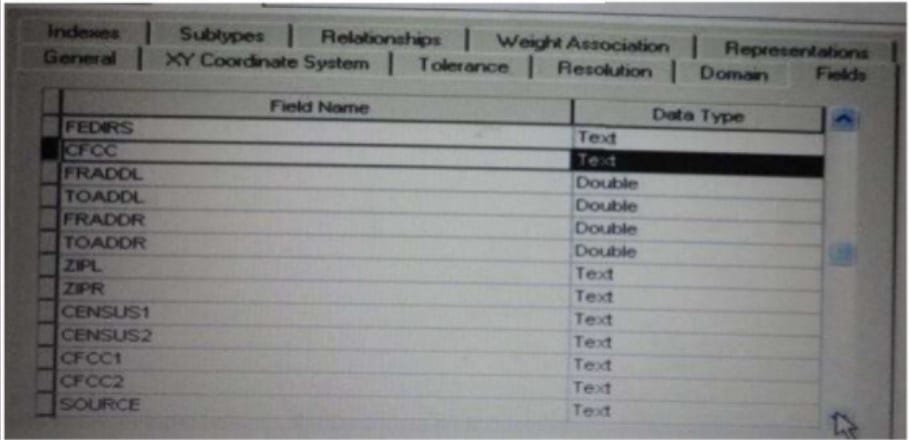
Which change needs to be made to the table in the exhibit in order to create subtypes based on the CFCC field?
A. A new field should be created to migrate the text values of CFCC to integers
B. A default CFCC value should be assigned
C. The data type of the CFCC field should be changed to Long integer
D. The allow subtypes property should be set to True
Why select/choose certbus.com?
Millions of interested professionals can touch the destination of success in exams by certbus.com. products which would be available, affordable, updated and of really best quality to overcome the difficulties of any course outlines. Questions and Answers material is updated in highly outclass manner on regular basis and material is released periodically and is available in testing centers with whom we are maintaining our relationship to get latest material.
![]()
![]()
Copyright © 2004-2025 certbus.com, All Rights Reserved.