EADA105 Online Practice Questions and Answers
An editor has built map topology and needs to modify the shape of neighboring polygons.
Which tool would maintain the shared polygon boundaries?
A. Reshape Edge Tool
B. Trance
C. Split Tool
D. Reshape Feature Tool
An ArcGIS user is preparing data for an aeronautical chart where the bearings and shapes of the features, such as coastline, need to be maintained for visual orientation.
What projection should be used?
A. Albers Equal Area
B. Equidistant Cylindrical
C. Azimuthal Equidistant
D. Lambert Conformal Conic
An ArcGIS Online user needs to combine areas that overlap or share a common edge into a single area.
What ArcGIS Online analysis tool should be used?
A. Extract Data
B. Dissolve Boundaries
C. Overlay Layers
D. Merge Layers
A GIS analyst regularly sends data to contractors. The datasets are stored in an enterprise geodatabase. The GIS analyst will prepare either a file geodatabase or shapefile depending on the contractor. Only a certain subset of the dataset should be sent, and this process will be scripted.
Which tool should the GIS analyst use to meet all requirements?
A. Copy
B. Append
C. Feature Class To Feature Class
D. Table To Table
A GIS technician has two polygon feature classes, A and B, which have overlapping features. The technician must remove the area of B from A.
Which tool should the technician use?
A. Clip
B. Union
C. Erase
D. Intersect
An ArcGIS user needs to fix a topology error in a street line feature class to remove a gap between an endpoint of a line and the edge of another line.
Which tool allows the user to repair this error in a single step?
A. Planarize Lines
B. Extend Line
C. Reshape Features
D. Line Intersection
The user has created a mosaic dataset to display temperature change over time and is in the process of configuring the Add Rasters To Mosaic Dataset geoprocessing tool.
To add the multidimensional data to the mosaic dataset, what raster type should be set?
A. NetCDF
B. DTED
C. HRE
D. ECRG
How should a GIS technician repair all broken data sources in a map at once?
A. Right-click Folders in the Project pane > Make a new folder connection > Navigate to the new file geodatabase location
B. Right-click Databases in the Project pane > Add Database > Navigate to the new file geodatabase location
C. Click the red exclamation point in the Contents pane > Change Data Source > Browse to new source
D. Click a broken layer in the Contents pane > Data Ribbon > Export Features
Refer to the exhibit.
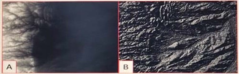
Which raster function will display image A as image B?
A. Shaded Relief
B. Slope
C. Hillshade
D. Aspect
An ArcGIS user has built a mosaic dataset using 25 rasters. However, upon adding the mosaic dataset to a blank map, the user finds that all rasters are NOT displaying. To troubleshoot the issue, the user zooms to the source resolution of one of the tiles and notices that the raster displays at 1:107000 but NOT at 1:997000.
Which tool needs to run to allow display of the rasters from 1:107000 to 1:997000?
A. Build Pyramids
B. Build Overviews
C. Build Footprints D. Build Boundary
A project calls for multiple remote teams of 10 to 15 editors to work collectively and independently on a data editing project. Each team's work needs to be isolated for the duration of the edits. When the edits are complete, they must be merged into a centralized communal dataset that will be verified for quality.
Which geodatabase type would be best suited to this workflow?
A. Enterprise
B. File
C. Workgroup
D. Personal
An ArcGIS user is printing a single map in a variety of page sizes.
What must the user do to ensure scalability for feature symbology and text within the map?
A. Scale map to fit printer paper within the Tiling options
B. Scale map elements proportionally to changes in page size
C. Convert marker symbols to polygons
D. Set reference scale in the data frame properties
A project calls for the creation of a single seamless raster dataset by merging 1000 separate rasters together. An analyst will use the Mosaic To New Raster tool to create the output. Adding the names of the 1000 rasters to the tool is a time-consuming task, so a model will be created to automate the process.
Which combination of ArcGIS Pro model utilities should be used to create a list of raster names that can be used as input for the Mosaic To New Raster tool?
A. Iterate Rasters and Collect Values
B. Iterate Files and Collect Values
C. Iterate Rasters and Select Data
D. Iterate Files and Select Data
An ArcGIS Pro user has a 2D point layer of trees with a Height attribute in the attribute table.
What is the most efficient workflow for the user to display the trees in 3D with realistic appearance and height?
A. Add the layer and symbolize it with a realistic 3D symbol
B. Add the layer as a Preset Layer using realistic trees
C. Add the layer and extrude based on the Height attribute
D. Add the layer and convert it to a multipatch feature class
A feature class has extensive metadata that contains many properties and documentation. The user needs to change how much of this metadata content is viewed, how it is displayed, specify which pages are included in the metadata editor, and how the pages work.
How should the user achieve this task?
A. Apply a metadata style
B. Modify the metadata XML file
C. Export the metadata
D. Validate Metadata
Why select/choose certbus.com?
Millions of interested professionals can touch the destination of success in exams by certbus.com. products which would be available, affordable, updated and of really best quality to overcome the difficulties of any course outlines. Questions and Answers material is updated in highly outclass manner on regular basis and material is released periodically and is available in testing centers with whom we are maintaining our relationship to get latest material.
![]()
![]()
Copyright © 2004-2025 certbus.com, All Rights Reserved.